
In the world of robotics, planning a path from one point to another isn’t just about finding a route—it’s about doing it intelligently.
If you’ve ever implemented Dijkstra’s algorithm, you know how powerful it is… but also how slow it can be when the map gets big. What if we could be smarter? What if we could guide the exploration toward the goal instead of blindly exploring everything?
That’s exactly what A* does.
In this tutorial, we’ll dive into the theory behind A*, then implement it as a Python ROS 2 node, using an occupancy grid and a simulated robot. By the end, you’ll be able to visualize in RViz how A* efficiently explores only the most promising cells—saving time, resources, and computation.
Let’s start with the same question we posed in the course:
Can we do any better than Dijkstra? Is there a faster way to reach the goal without exploring in all directions?
Yes—and it’s called A*.
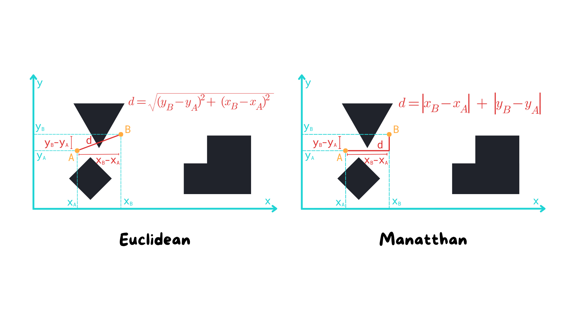
While Dijkstra explores nodes uniformly, A* evaluates each possible move with a simple yet powerful formula:
$$f(n) = g(n) + h(n)$$
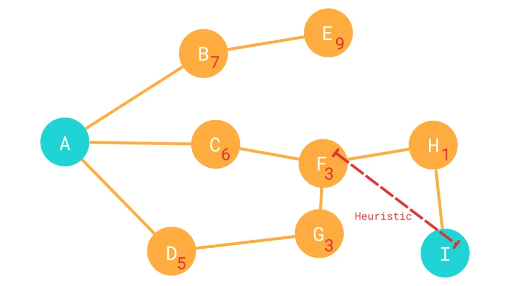
This heuristic is what gives A* its directionality. It guesses which paths are likely to lead to the goal, and gives them priority.
In the course, we visualized two different heuristics:
Since our robot operates on a 2D occupancy grid where it can only move in four directions (up, down, left, right), Manhattan distance is the perfect fit.
Here’s how it looks in code:
					def manhattan_distance(self, node: GraphNode, goal_node: GraphNode):
        return abs(node.x - goal_node.x) + abs(node.y - goal_node.y)
This distance doesn’t consider walls or obstacles—it’s just an estimate. But it’s enough to guide the algorithm intelligently.
 Here’s the full code:
					#!/usr/bin/env python3

import rclpy
from rclpy.node import Node
from nav_msgs.msg import OccupancyGrid, Path
from geometry_msgs.msg import PoseStamped, Pose
from rclpy.qos import QoSProfile, DurabilityPolicy
from tf2_ros import Buffer, TransformListener, LookupException
from queue import PriorityQueue

class GraphNode:
    def __init__(self, x, y, cost=0, heuristic=0, prev=None):
        self.x = x
        self.y = y
        self.cost = cost
        self.heuristic = heuristic
        self.prev = prev

    def __lt__(self, other):
        return (self.cost + self.heuristic) < (other.cost + other.heuristic)

    def __eq__(self, other):
        return self.x == other.x and self.y == other.y

    def __hash__(self):
        return hash((self.x, self.y))

    def __add__(self, other):
        return GraphNode(self.x + other[0], self.y + other[1])

class AStarPlanner(Node):
    def __init__(self):
        super().__init__("a_star_node")
        self.tf_buffer = Buffer()
        self.tf_listener = TransformListener(self.tf_buffer, self)

        map_qos = QoSProfile(depth=10)
        map_qos.durability = DurabilityPolicy.TRANSIENT_LOCAL

        self.map_sub = self.create_subscription(
            OccupancyGrid, "/map", self.map_callback, map_qos
        )
        self.pose_sub = self.create_subscription(
            PoseStamped, "/goal_pose", self.goal_callback, 10
        )
        self.path_pub = self.create_publisher(Path, "/a_star/path", 10)
        self.map_pub = self.create_publisher(OccupancyGrid, "/a_star/visited_map", 10)

        self.map_ = None
        self.visited_map_ = OccupancyGrid()

    def map_callback(self, map_msg: OccupancyGrid):
        self.map_ = map_msg
        self.visited_map_.header.frame_id = map_msg.header.frame_id
        self.visited_map_.info = map_msg.info
        self.visited_map_.data = [-1] * (map_msg.info.height * map_msg.info.width)

    def goal_callback(self, pose: PoseStamped):
        if self.map_ is None:
            self.get_logger().error("No map received!")
            return

        self.visited_map_.data = [-1] * (self.visited_map_.info.height * self.visited_map_.info.width)

        try:
            map_to_base_tf = self.tf_buffer.lookup_transform(
                self.map_.header.frame_id, "base_footprint", rclpy.time.Time()
            )
        except LookupException:
            self.get_logger().error("Could not transform from map to base_footprint")
            return

        map_to_base_pose = Pose()
        map_to_base_pose.position.x = map_to_base_tf.transform.translation.x
        map_to_base_pose.position.y = map_to_base_tf.transform.translation.y
        map_to_base_pose.orientation = map_to_base_tf.transform.rotation

        path = self.plan(map_to_base_pose, pose.pose)
        if path.poses:
            self.get_logger().info("Shortest path found!")
            self.path_pub.publish(path)
        else:
            self.get_logger().warn("No path found to the goal.")

    def plan(self, start: Pose, goal: Pose):
        # Define possible movement directions
        explore_directions = [(-1, 0), (1, 0), (0, -1), (0, 1)]

        # Priority queue with custom comparison for A* based on cost + heuristic
        pending_nodes = PriorityQueue()
        visited_nodes = set()

        start_node = self.world_to_grid(start)
        goal_node = self.world_to_grid(goal)
        start_node.heuristic = self.manhattan_distance(start_node, goal_node)
        pending_nodes.put(start_node)

        while not pending_nodes.empty() and rclpy.ok():
            active_node = pending_nodes.get()

            # Goal found!
            if active_node == goal_node:
                break

            # Explore neighbors
            for dir_x, dir_y in explore_directions:
                new_node: GraphNode = active_node + (dir_x, dir_y)

                if (new_node not in visited_nodes and self.pose_on_map(new_node) and
                    self.map_.data[self.pose_to_cell(new_node)] == 0):

                    new_node.cost = active_node.cost + 1
                    new_node.heuristic = self.manhattan_distance(new_node, goal_node)
                    new_node.prev = active_node

                    pending_nodes.put(new_node)
                    visited_nodes.add(new_node)

            self.visited_map_.data[self.pose_to_cell(active_node)] = -106
            self.map_pub.publish(self.visited_map_)

        path = Path()
        path.header.frame_id = self.map_.header.frame_id
        while active_node and active_node.prev and rclpy.ok():
            last_pose: Pose = self.grid_to_world(active_node)
            last_pose_stamped = PoseStamped()
            last_pose_stamped.header.frame_id = self.map_.header.frame_id
            last_pose_stamped.pose = last_pose
            path.poses.append(last_pose_stamped)
            active_node = active_node.prev

        path.poses.reverse()
        return path

    def manhattan_distance(self, node: GraphNode, goal_node: GraphNode):
        return abs(node.x - goal_node.x) + abs(node.y - goal_node.y)

    def pose_on_map(self, node: GraphNode):
        return 0 <= node.x < self.map_.info.width and 0 <= node.y < self.map_.info.height

    def world_to_grid(self, pose: Pose) -> GraphNode:
        grid_x = int((pose.position.x - self.map_.info.origin.position.x) / self.map_.info.resolution)
        grid_y = int((pose.position.y - self.map_.info.origin.position.y) / self.map_.info.resolution)
        return GraphNode(grid_x, grid_y)

    def grid_to_world(self, node: GraphNode) -> Pose:
        pose = Pose()
        pose.position.x = node.x * self.map_.info.resolution + self.map_.info.origin.position.x
        pose.position.y = node.y * self.map_.info.resolution + self.map_.info.origin.position.y
        return pose

    def pose_to_cell(self, node: GraphNode):
        return node.y * self.map_.info.width + node.x


def main(args=None):
    rclpy.init(args=args)
    node = AStarPlanner()
    rclpy.spin(node)
    rclpy.shutdown()

if __name__ == '__main__':
    main()
 Hands On: The fun part of the code
Now let’s build the actual planner.
Since this planner shares a lot with the Dijkstra version we already implemented, we’ll reuse that script as a starting point.
In your ROS 2 workspace:
cp dijkstra_planner.py a_star_planner.py
Open the file and rename the class:
					class AStarPlanner(Node):
    def __init__(self):
        super().__init__('a_star_node')
Update the topics it will publish to:
					self.path_pub = self.create_publisher(Path, "/a_star/path", 10)
self.map_pub = self.create_publisher(OccupancyGrid, "/a_star/visited_map", 10)
In Dijkstra, each node only tracked its cost and parent. A* adds a heuristic value.
So modify the GraphNode class:
					def __init__(self, x, y, cost=0, heuristic=0, prev=None):
    self.x = x
    self.y = y
    self.cost = cost
    self.heuristic = heuristic
    self.prev = prev
Update how nodes are compared inside the priority queue:
					def __lt__(self, other):
    return (self.cost + self.heuristic) < (other.cost + other.heuristic)
This ensures that nodes with the lowest combined cost and estimate are explored first.
In your planner, after converting the robot’s current pose and the goal into grid coordinates:
					start_node = self.world_to_grid(start)
goal_node = self.world_to_grid(goal)
You can now assign the heuristic to the start node:
start_node.heuristic = self.manhattan_distance(start_node, goal_node)
Then, in your main exploration loop, assign it to each neighbor node:
new_node.heuristic = self.manhattan_distance(new_node, goal_node)
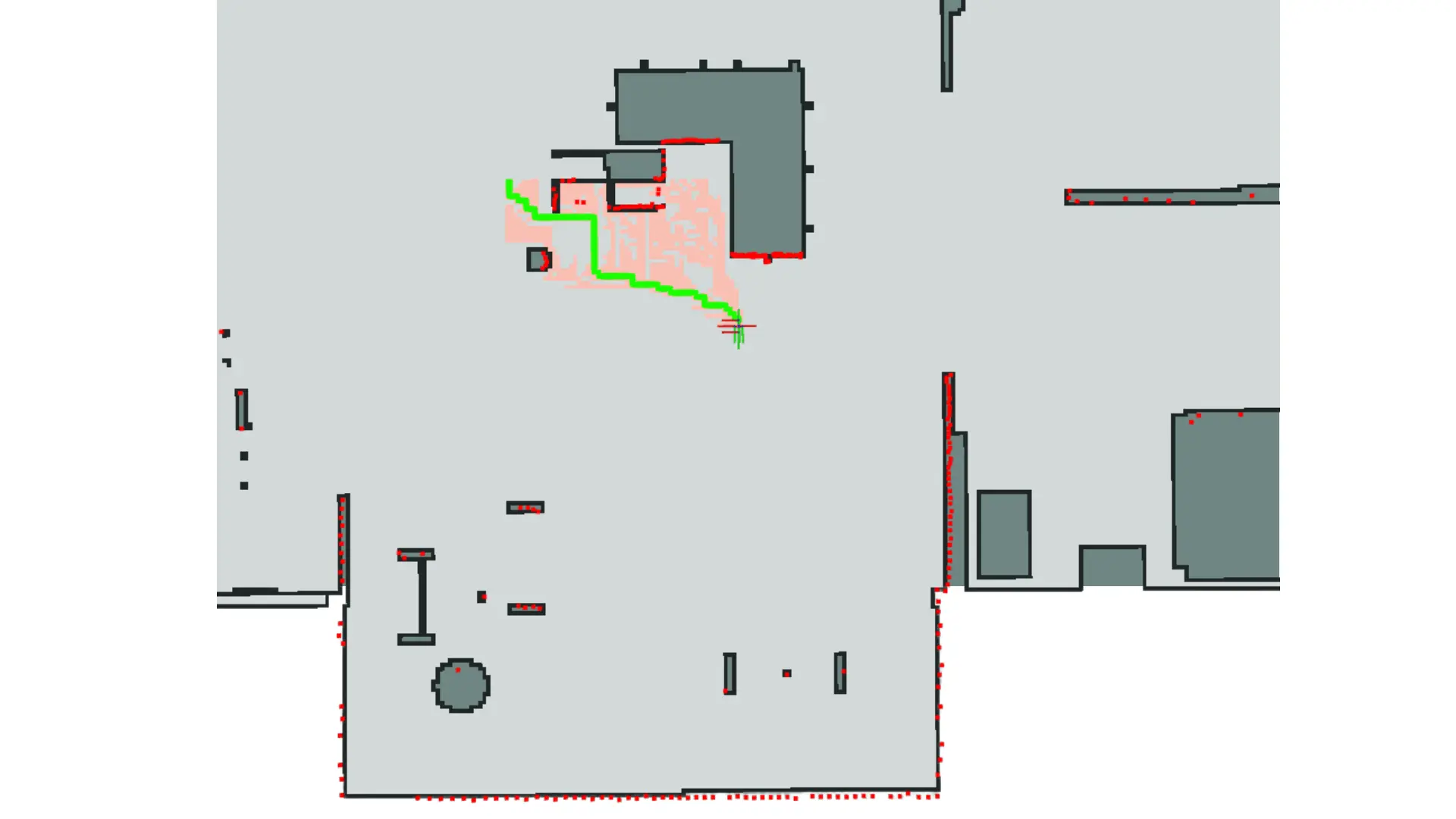
We want to distinguish A* from Dijkstra visually. Let’s mark the visited cells in orange using a different value:
self.visited_map_.data[self.pose_to_cell(active_node)] = -106
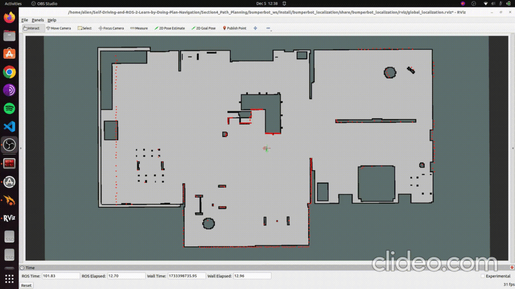
In RViz, this will appear as a bright orange overlay on the grid—clearly showing the path of exploration.
Open CMakeLists.txt of your package and make sure to install the new file:
					install(PROGRAMS
  ${PROJECT_NAME}/a_star_planner.py
  DESTINATION lib/${PROJECT_NAME}
)
Then build the workspace:
					cd bumperbot_ws
colcon build
Launch the robot simulation:
ros2 launch bumperbot_bringup simulated_robot.launch.py
Then launch your planner in a new terminal:
ros2 run bumperbot_planning a_star_planner
In RViz:
/a_star/path to visualize the calculated path/a_star/visited_map and set display type to CostmapYou’ll immediately see A* in action—moving quickly and efficiently toward the target!
Try sending goals both near and far from the robot’s current location.
You’ll notice a clear pattern: A* prioritizes cells in the direction of the goal, skipping irrelevant parts of the map.
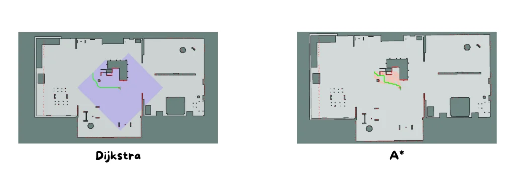
A* is fast, but it’s not perfect. If the heuristic is not admissible (i.e. it overestimates the cost), A* might return a non-optimal path.
In our implementation, Manhattan distance is admissible—so we’re safe. But always remember:
The heuristic is just a guess, not the truth.
By integrating a simple heuristic into our existing path planner, we made our robot smarter—and much faster at navigating to its goal.
With just a few modifications, the A* planner in Python is now ready to explore any occupancy grid efficiently, intelligently, and with a visual feedback that makes debugging and testing a joy.
Assemble your robot and get started to learn Robotics!